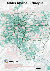
We are happy to provide you with current printable map of Addis Ababa, the capital city of Ethiopia in East Africa.
It shows the 10 sub cities and well-known areas.
Addis Ababa was devided in 10 subcities: Addis Ketema, Akaki Kaliti, Arada, Bole, Gulale, Kirkos, Kolfe Keran, Lideta, Nefas Silk, Yeka.
There is a new subcity “Lemi Kura” which is not yet included in this map and will be included later.
Download the Map
Choose file format that fits your use case: We provide a 300dpi High-Resolution version for printing on A4 paper, a 72dpi Low-Resolution PNG for on screen display as well as as PDF version.
Download “Addis Ababa Map - PDF Version” 2021-01-addis-ababa-ethiopia.pdf – 23.19 MB
Download “Addis Ababa Map (Low Resolution PNG)” 2021_10_2-addis-ababa-ethiopia-72dpi.png – 980.98 KB
The map data is licensed under OdBL by OpenStreetMap contributors.
If you need a custom map, we can produce such custom maps as well. Just send us your requirements.
Map Contents
The 10 subcities are shown. Additionally the map includes the location of following areas:
- Addis Ketema
- Addis Sefer
- Adiss
- Agusta
- Akaki-Kaliti
- Amanuel Area
- American Gibi
- Arat Kilo
- Ayat
- Ayertena
- Bantyiketu
- Beg Tera
- Beherawi
- Bekelo Bet
- Berberee Berenda
- Besrat Gebriel
- Bole
- Bole Ayat
- Bole Mikael
- Bulgariya Mazoriya
- Cabana
- Ched Tera
- Coca
- Darmar
- District 3
- Doro Tera
- Gebre Kristos Bete Kristiyan
- Geja Seffer
- Gerji
- Ghiliffalegn Stream
- Giorgis
- Goma Kuteba
- Gotera
- Great Acachi
- Gulele Bota
- Haile Garment
- Hana
- Harbu Shet’
- Irtu Bota
- Jemo
- Jos Hanssen
- Kara
- Kara Alo
- Kazanchis
- Kera
- Ketena Hulet
- Kirkos
- Kolfe Keranio
- Kolfe Keranyo
- Korech Tera
- Kotebe
- Kurtume Stream
- Lafto
- Lancha
- Lebu
- Lebu Mebrathayil
- Legahar
- Lideta
- Lideta
- Lideta Gebri’El Bete Kristiyan
- Mechare Meda
- Megenagna
- Mekanisa
- Mekanisa Abo
- Menahereya Kazanchis
- Menisa
- Meshuwalekiya
- Meskel Flower
- Mesob Tera
- Mexico
- Microlink Project
- Minalesh Tera
- Mobil
- Molla Maru
- Nefas Silk-Lafto
- Olympia
- Piassa (piazza)
- Repi
- Riche
- Rwanda
- Sarbet
- Saris
- Saris Abo Area
- Sebategna
- Sengatera
- Shekela Tera
- Shema Tera
- Somale Tera
- Soste Kuter Mazoria (Total)
- Sunshine Real state
- Tekelehaymanot
- Tor Hiylloch
- Urael
- Vatican
- Wello Sefer
- Yedejazmach Alula Irsha
- Yeka
- Yeka
- Yeka Bole Bota
- Zenebework
Thank you for providing Addis Abeba’s 10 sub-cities map. It is a great service for travelers.
Hello,
I have the new subcity / woreda shapefile if you need it. Would you please send me the “suburb”/neighborhood shapefile thank you.
Please attached Addis Ababa sub city with specific area ( Yeka sub city includes Ferensay Legasion, ….)
What do you mean exactly?
Alex
update the map, include Lemikura sub-city
Thanks for the feedback. We don’t have the data yet, If you are a OpenStreetMap contributor, you can help by updating it on osm.org 😉
it was better to use main or secondary roads rather than residential roads, for cartographic generalization and simplification purpose.